
CHINESE JOURNAL OF PARASITOLOGY AND PARASITIC DISEASES ›› 2020, Vol. 38 ›› Issue (4): 417-422.doi: 10.12140/j.issn.1000-7423.2020.04.003
• ORIGINAL ARTICLES • Previous Articles Next Articles
XIA Shang1,2, XUE Jing-bo1,2, GAO Feng-hua3, LV Shan1,2, XU Jing1,2, ZHANG Shi-qing3, LI Shi-zhu1,2,*( )
)
Received:2020-08-10
Online:2020-08-30
Published:2020-09-09
Contact:
LI Shi-zhu
E-mail:lisz@chinacdc.cn
Supported by:CLC Number:
XIA Shang, XUE Jing-bo, GAO Feng-hua, LV Shan, XU Jing, ZHANG Shi-qing, LI Shi-zhu. Sentinel-1A radar remote sensing-based modeling for quick identification of potential risk areas of schistosomiasis transmission after flood[J]. CHINESE JOURNAL OF PARASITOLOGY AND PARASITIC DISEASES, 2020, 38(4): 417-422.
Add to citation manager EndNote|Ris|BibTeX
URL: https://www.jsczz.cn/EN/10.12140/j.issn.1000-7423.2020.04.003
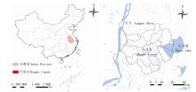
Fig. 1
The geographical location of Dangtu County, Anhui Province (China Administrative Division Map, the Resource and Environment Science and Data Center, Chinese Acdemy of Sciences)
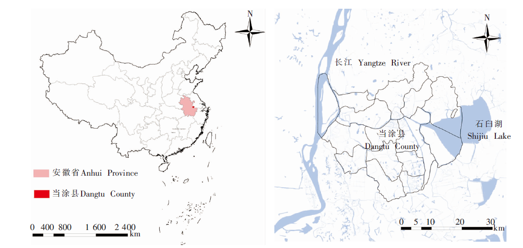

Fig. 2
Binary images of water bodies and land before and after the floodimage on May 15 (A)and July 16(B), 2020, extracted from Sentinel-1A satellite SAR images in Dangtu County, Anhui Province
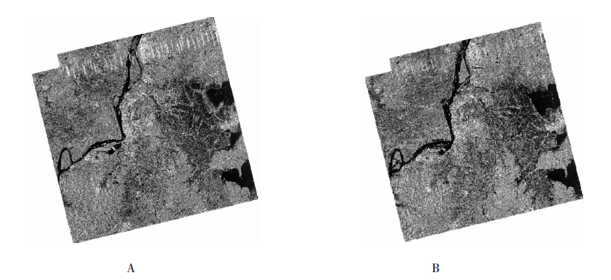
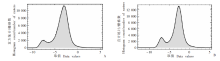
Fig. 3
Histograms of water body extraction based on SAR images on May 15(A)and on July 16(B), 2020 in Dangtu County, Anhui Province
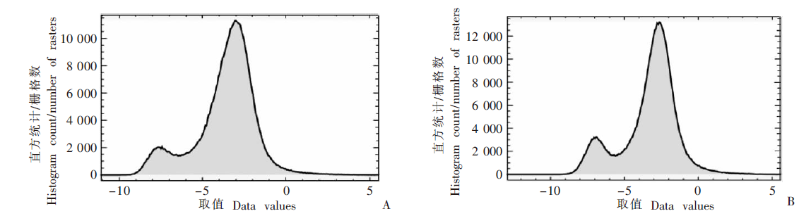
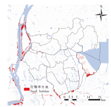
Fig. 4
The distribution of snail habitats in Dangtu County, Anhui Province
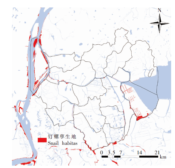
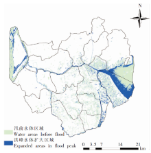
Fig. 5
Comparison of water body distribution before and after the flood in Dangtu County, Anhui Province
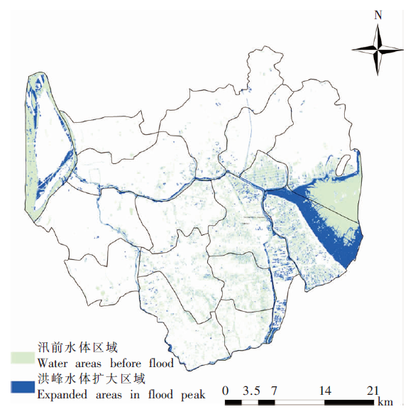
Fig. 6
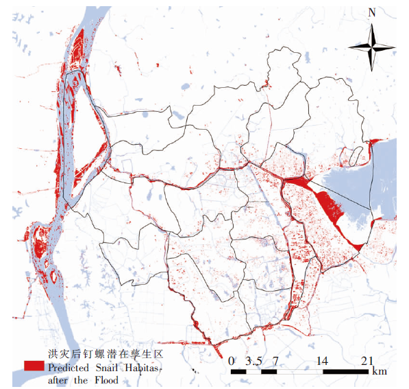
Map of potential snail habitat distribution after flood in Dangtu County, Anhui Province
| [1] | Xu J, Lv S, Cao CL, et al. Progress and challenges of schistosomiasis elimination in China[J]. Chin J Schisto Control, 2018,30(6):605-609. (in Chinese) |
| ( 许静, 吕山, 曹淳力, 等. 我国血吸虫病消除工作进展及面临的挑战[J]. 中国血吸虫病防治杂志, 2018,30(6):605-609.) | |
| [2] | Lv S, Xu J, Cao CL, et al. China fighting against schistosomiasis for 70 years: progress and experience[J]. Chin J Parasitol Parasit Dis, 2019,37(5):514-519. (in Chinese) |
| ( 吕山, 许静, 曹淳力, 等. 我国血吸虫病防治70年历程与经验[J]. 中国寄生虫学与寄生虫病杂志, 2019,37(5):514-519) | |
| [3] | Cao CL, Li SZ, Zhou XN. Impact of schistosomiasis transmission by catastrophic flood damage and emergency response in China[J]. Chin J Schisto Control, 2016,28(6):618-623. (in Chinese) |
| ( 曹淳力, 李石柱, 周晓农. 特大洪涝灾害对我国血吸虫病传播的影响及应急处置[J]. 中国血吸虫病防治杂志, 2016,28(6):618-623.) | |
| [4] | Yi XM, Wang ZL, Wang QZ, et al. The long-term effects of flood on the prevalence of schistosomiasis[J]. Trop Dis Parasitol, 2010,8(4):192-194. (in Chinese) |
| ( 尹晓梅, 王珍丽, 汪奇志, 等. 长江特大洪水溃堤洲滩灾后血吸虫病疫情监测[J]. 热带病与寄生虫学, 2010,8(4):192-194.) | |
| [5] | Ge JH, Zhang SQ, Wang TP, et al. Effects of flood on the prevalence of schistosomiasis in Anhui Province in 1998[J]. Trop Dis Parasitol, 2004,2(3):131-134. (in Chinese) |
| ( 葛继华, 张世清, 汪天平, 等. 1998年特大洪水对安徽省血吸虫病流行的影响[J]. 热带病与寄生虫学, 2004,2(3):131-134.) | |
| [6] | Zhang SQ, Ge JH, Wang TP, et al. Analysis on the epidemic situation of schistosomiasis at Fengyi marshland after dam break by flood in 1998[J]. Pract Prev Med, 2001,8(5):323-324. (in Chinese) |
| ( 张世清, 葛继华, 汪天平, 等. 凤仪洲1998年洪水溃堤后血吸虫病疫情分析[J]. 实用预防医学, 2001,8(5):323-324.) | |
| [7] | Wang ZL, Gao J, Tao B, et al. Preliminary study on applying high resolution CBERS images to identify Oncomelania snail habitats in lake and marshland regions[J]. Chin J Schisto Control, 2012,22(6):640-644. (in Chinese) |
| ( 王增亮, 高杰, 陶波, 等. 应用高分辨率中巴资源卫星遥感图像探测湖沼地区钉螺孳生地的初步研究[J]. 中国血吸虫病防治杂志, 2012,22(6):640-644.) | |
| [8] | Zhou YB. Strengthening the research and application of spatial epidemiology to pro-mote precise prevention and control of parasitic diseases in China[J]. Chin J Schisto Control, 2019,31(4):356-357. (in Chinese) |
| ( 周艺彪. 加强空间流行病学研究与应用助推我国寄生虫病精准防控[J]. 中国血吸虫病防治杂志, 2019,31(4):356-357) | |
| [9] | Liu D, Yang YY, Zhou YD, et al. High spectral resolution lidar for atmosphere remote sensing: a review[J]. Infr Las Eng, 2015,44(9):7-18. (in Chinese) |
| ( 刘东, 杨甬英, 周雨迪, 等. 大气遥感高光谱分辨率激光雷达研究进展[J]. 红外与激光工程, 2015,44(9):7-18.) | |
| [10] | Xiao X, Zhang L. Research on comparison and selection methods of remote sensing data sources for geographic national conditions monitoring[J]. Bull Sur Map, 2019(8):116-120. (in Chinese) |
| ( 肖昶, 张莉. 地理国情监测遥感数据源比选方法研究[J]. 测绘通报, 2019(8):116-120.) | |
| [11] | Wu P. Analysis on the endemic situation of schistosomiasis from 2006 to 2012 in Dangtu County, Anhui Province[J]. Trop Dis Parasitol, 2014,12(2):94-95. (in Chinese) |
| ( 吴萍. 2006-2012年安徽当涂县血吸虫病疫情分析[J]. 热带病与寄生虫学, 2014,12(2):94-95.) | |
| [12] | Gao FH, Zhang SQ, Wang TP, et al. Investigation of Oncomelania hupensis snails in Anhui Province in 2016[J]. Chin J Schisto Control, 2018,30(5):19-25. (in Chinese) |
| ( 高风华, 张世清, 汪天平, 等. 2016年安徽省钉螺调查结果分析[J]. 中国血吸虫病防治杂志, 2018,30(5):19-25.) | |
| [13] | Xia CC, Lu CF, Li S, et al. Maximum entropy model versus remote sensing-based methods for extracting Oncomelania hupensis snail habitats[J]. Chin J Schisto Control, 2017,29(1):12-17. (in Chinese) |
| ( 夏聪聪, 卢成芳, 李思, 等. 基于最大熵模型和遥感的两种钉螺孳生地提取方法的比较[J]. 中国血吸虫病防治杂志, 2017,29(1):12-17.) | |
| [14] | Wang ZL, Zhu R. Zhang ZJ, et al. Identification of snail habitats in the Poyang Lake region, based on the application of indices on joint normalized difference vegetation and water[J]. Chin J Epidemiol, 2012,33(8):823-827. (in Chinese) |
| ( 王增亮, 朱蓉, 张志杰, 等. 联合应用归一化水体和植被指数提取鄱阳湖区钉螺孳生地的研究[J]. 中华流行病学杂志, 2012,33(8):823-827.) | |
| [15] | Cao ZG, Wang TP, He JC, et al. Evaluation on the effect of comprehensive control strategy of schistosomiasis with emphasis on infection source control in Anhui province[J]. Chin J Prev Med, 2012,46(2):114-118. (in Chinese) |
| ( 操治国, 汪天平, 何家昶, 等. 安徽省实施以传染源控制为主的血吸虫病综合防治策略效果评价[J]. 中华预防医学杂志, 2012,46(2):114-118.) | |
| [16] | Gao FH, Zhang SQ, Wang TP, et al. Endemic status of schistosomiasis in Anhui Province in 2018[J]. Trop Dis Parasitol, 2020,18(1):41-45. (in Chinese) |
| ( 高风华, 张世清, 汪天平, 等. 2018 年安徽省血吸虫病疫情分析[J]. 热带病与寄生虫学, 2020,18(1):41-45.) | |
| [17] | Wang YJ, Li SZ, Jiang QW, et al. Progress of spatial epidemiology applied to prevention and control of schistosomiasis[J]. Chin J Schisto Control, 2019,31(1):53-57. (in Chinese) |
| ( 王英鉴, 李石柱, 姜庆五, 等. 空间流行病学在血吸虫病防控实践中的应用进展[J]. 中国血吸虫病防治杂志, 2019,31(1):53-57.) | |
| [18] | Xue JB, Zhang LJ, Wang Q, et al. Application of high resolution remote sensing technology in research of schistosomiasis surveillance[J]. Chin J Schisto Control, 2015,27(5):551-554. (in Chinese) |
|
( 薛靖波, 张利娟, 王强, 等. 高分辨率遥感技术在日本血吸虫病监测中的应用[J]. 中国血吸虫病防治杂志, 2015,27(5):551-554)
doi: 10.16250/j.32.1374.2015072 |
|
| [19] | Jia SC, Xue DJ, Li CR, et al. Study on new method for water area information extraction based on Sentinel-1 data[J]. Yangtze River, 2019,50(2):213-217. (in Chinese) |
| ( 贾诗超, 薛东剑, 李成绕, 等. 基于Sentinel-1数据的水体信息提取方法研究[J]. 人民长江, 2019,50(2):213-217.) | |
| [20] | Zeng FL, Li L, Wan LH. SAR-based fast flood mapping using Sentinel-1 imagery[J]. Geo World, 2015,22(5):100-103. (in Chinese) |
| ( 曾玲方, 李霖, 万丽华. 基于Sentinel-1卫星SAR数据的洪水淹没范围快速提取[J]. 地理信息世界, 2015,22(5):100-103.) | |
| [21] | Zhang SQ, Wang TP, Ge JH, et al. Influence on the diffusion of snail by flooding in Anhui Province[J]. Trop Dis Parasitol, 2004,2(2):90-94. (in Chinese) |
| ( 张世清, 汪天平, 葛继华, 等. 洪涝灾害对安徽省钉螺扩散的影响[J]. 热带病与寄生虫学, 2004,2(2):90-94.) |
| [1] | LI Jie, WEN Yusong, LI Zhaojun. Effect of tourism development on schistosomiasis control in China [J]. CHINESE JOURNAL OF PARASITOLOGY AND PARASITIC DISEASES, 2023, 41(3): 355-360. |
| [2] | CHEN Lin, ZHU Jifeng, QIU Jingfan, XU Zhipeng, ZHANG Donghui, CHEN Lu, HE Jian, LI Wei, YANG Kun, JI Minjun. Design and development of a virtual simulation project for schistosomiasis control based on the One Health concept [J]. CHINESE JOURNAL OF PARASITOLOGY AND PARASITIC DISEASES, 2023, 41(1): 81-84. |
| [3] | FENG Jia-xin, GONG Yan-feng, LUO Zhuo-wei, WANG Wei, CAO Chun-li, XU Jing, LI Shi-zhu. Scientific basis of strategies for schistosomiasis control and prospect of the 14th Five-Year Plan in China [J]. CHINESE JOURNAL OF PARASITOLOGY AND PARASITIC DISEASES, 2022, 40(4): 428-435. |
| [4] | CHEN Bing, ZHANG Guo-li, ZHANG Gao-hong. Research progress on clinical trials of schistosomiasis vaccine candidates [J]. CHINESE JOURNAL OF PARASITOLOGY AND PARASITIC DISEASES, 2022, 40(4): 511-515. |
| [5] | GAO Yuan, HU Yuan, CAO Jian-ping. Research progress on the role of immune cells in liver fibrosis due to schistosomiasis [J]. CHINESE JOURNAL OF PARASITOLOGY AND PARASITIC DISEASES, 2022, 40(1): 88-93. |
| [6] | GUO Su-ying, ZHU Hong-qing, CAO Chun-li, DENG Wang-ping, BAO Zi-ping, JIA Tie-wu, LI Yin-long, LV Chao, QIN Zhi-qiang, ZHANG Li-juan, FENG Ting, YANG Fan, LV Shan, XU Jing, LI Shi-zhu. Risk assessment of schistosomiasis transmission along the middle and lower reaches of Yangtze River after flooding in 2020 [J]. CHINESE JOURNAL OF PARASITOLOGY AND PARASITIC DISEASES, 2021, 39(6): 753-758. |
| [7] | SHI Liang, XIONG Chun-rong, LIU Mao-mao, WEI Xiu-shen, ZHANG Jian-feng, WANG Xin-yao, WANG Tao, HANG De-rong, YANG Hai-tao, YANG Kun. Evaluation of efficacy of visual intelligent recognition model for Oncomelania hupensis based on deep learning technology [J]. CHINESE JOURNAL OF PARASITOLOGY AND PARASITIC DISEASES, 2021, 39(6): 764-770. |
| [8] | LI Bo, ZHANG Cong, SHAN Xiao-wei, YI Jia, TU Zhen, HE Hui, TANG Li, ZHU Hong, LIU Jian-bing. Evaluation of the pathogen detection capacity in standardized schistosomiasis laboratories in Hubei Province [J]. CHINESE JOURNAL OF PARASITOLOGY AND PARASITIC DISEASES, 2021, 39(5): 572-576. |
| [9] | WU Jia-li, LI Bo, LIU Si, TU Zu-wu, TANG Li, TU Zhen, ZHOU Xiao-rong, SUN Ling-cong, XIAO Ying, ZHU Hong. Assessment of transmission risk of human schistosomiasis japonica based on human population antibody level in Hubei Province [J]. CHINESE JOURNAL OF PARASITOLOGY AND PARASITIC DISEASES, 2021, 39(5): 578-584. |
| [10] | HU Fei, GAO Zhu-lu, YUAN Min, LI Zhao-jun, LI Yi-feng, LIU Yue-min, LI Jian-ying, XIE Shu-ying, WEN Yu-song, LIN Dan-dan. Changing trends of schistosome infection and liver fibrosis among residents in the Poyang Lake region [J]. CHINESE JOURNAL OF PARASITOLOGY AND PARASITIC DISEASES, 2021, 39(5): 629-636. |
| [11] | LIU Rong, ZHANG Jian-feng, YAN Xiao-lan, WEN Li-yong. Comparative study of SF-36 and EQ-5D-5L in evaluating quality of life for patients with advanced schistosomiasis [J]. CHINESE JOURNAL OF PARASITOLOGY AND PARASITIC DISEASES, 2021, 39(5): 639-645. |
| [12] | LIU Rong, WEN Li-yong. New progress in basic and clinical research of advanced schistosomiasis [J]. CHINESE JOURNAL OF PARASITOLOGY AND PARASITIC DISEASES, 2021, 39(4): 429-436. |
| [13] | HONG Zhong, WU Ling-ling, WANG Li-ping, XU Jing. Progress and challenges on global schistosomiasis control [J]. CHINESE JOURNAL OF PARASITOLOGY AND PARASITIC DISEASES, 2021, 39(4): 514-519. |
| [14] | WANG Li-ping, QIN Zhi-qiang, LV Shan, LI Shi-zhu, ZHOU Xiao-nong, XU Jing. Prevalence and challenges in elimination of schistosomiasis mekongi [J]. CHINESE JOURNAL OF PARASITOLOGY AND PARASITIC DISEASES, 2020, 38(6): 758-763. |
| [15] | NI Qing-xiang, RUAN Wei, YAO Li-nong, NI Dan-dan, XIANG Fang-lv. Laboratory test and epidemiological investigation of the first imported case of schistosomiasis haematobia in Wenzhou City [J]. CHINESE JOURNAL OF PARASITOLOGY AND PARASITIC DISEASES, 2020, 38(5): 667-669. |
| Viewed | ||||||
|
Full text |
|
|||||
|
Abstract |
|
|||||